In the first 15 months after the MH17 disaster the Dutch Safety Board (DSB) had an important part to play, as they conducted the research that had to uncover the causes (not the culprits) of the plane crash.
Contrary to what the JIT showed to the public – a lot of social media material and intercepted calls, as we saw in parts 1-5 of this series – the DSB had commissioned two professional organizations to conduct a clear technical investigation into damage pattern analysis on the MH17 wreckage, a possible device and/or weapon that matched it and, from there on, missile trajectory calculations to establish a launch site.
On its own this would be a good way to start a thorough and trustworthy forensic investigation into the origins of a shoot down. Their results would also lay down a firm framework for the operational boundaries the JIT had to reckon with. Or was it the other way around and was the framework set by the JIT, ie. their most influential member, Ukraine, to get to a desired outcome?
Part 6. Support from the Dutch Safety Board
6.1 Political interference in the investigations
From the onset of the investigations there was strong interference from the political realm. In the first place there was no official communication with the representatives of the Donetsk Peoples Republic (DPR), the self-acclaimed authorities of the separatist controlled area around Donetsk.
Political motives were at hand. As followers of the US supported neoliberal/neofascist coup in Ukraine of February 2014 and the ousting of president Yanukovich, the Dutch government chose to not endorse the DPR authorities by doing official business with them. This would lead to severe difficulties and delays in the salvaging of the bodies of the victims, the black boxes and parts of the plane wreckage.
This complication lead to shameful smearing of the local rescue workers on site, who did their best to recover the bodies, but were accused of unrespectful conduct by western media and even by Dutch official Frans Timmermans in a speech before the UN General Council. This was a black page in the history of Dutch diplomacy indeed.
In reality the OSCE, the European monitoring mission, had advised the local authorities to keep the crash site as untouched as possible. When no one showed up to recover the marked human remains in the field, which were lying in the burning sun for days, the DPR decided to salvage them themselves. The rescue team collected the bodies with care and conserved them in cooled train wagons, that could (and would) take course to Kharkiv, outside of conflict area.
The black boxes were found, but no Dutch or any other official western team would pick them up in order to avoid official contacts with the DPR authorities. So Malaysia took the forefront, got full cooperation from the DPR and took over the black boxes without problems for a read out in Farnborough, Great Britain. Ukraine was not amused, which probably was a main reason to keep the Malaysians out of the JIT investigations for months.

In this first, most important period of the investigation these events led to the formation of a Joint Investigation Team consisting of the Netherlands (193 victims), Australia (27 victims), Ukraine (official jurisdiction over the crash site, but no de facto control) and Belgium (4 victims), assisted by GB (home of the manufacturer of the Rolls Royce engines; read out the black boxes) and the US (home of Boeing; intelligence). Actually this was an all (pro-)NATO enterprise.
 Victims per country (From the DSB report, Dutch version)
A lot of confidence in our own morally splendid conduct – not incidentally leading to racism towards non-western nations – has been tied to western rule since the 16th century. It is inconceivable for the western audience there could exist something like individual or political interests behind this kind of investigations, when performed by offices rooted in our own culture of moral purity. Maybe this could be an explanation for the persistent confidence in everything the DSB and the JIT conveyed to the public, as if our police and prosecutors never could be compromised by unwestern things like corruption or strong political incentives.
Maybe this also was an explanation for the difficult relations with Malaysia and Russia. Soon after the initial investigations started, Russian Foreign Secretary Sergey Lavrov lamented the lack of openness, as was also referred to in documents of the Interdepartementale Commissie Crisis beheersing (Dutch government crisis control center, ICCb) [see the protocols of the center in this pdf report].
Buk manufacturer Almaz Antei was asked by the DSB to provide information about weapon performance, but their full technical expertise was only partly used and facts that conflicted the “main scenario” (Buk M1, south of Snizhne) were set aside altogether [see appendix V to the final report by the DSB for discussions]. In the end the DSB used some secret parameters provided by NATO. The DSB also led some field experiments with Finnish Buks, because Ukraine refused to cooperate. Remarkably, in this respect JIT member Ukraine showed to be a reluctant provider of information.
As this was the first time the ICCb had operated in the field, its conduct was investigated afterwards for evaluation. In a report the Technical University Enschede asserted that the National Coordinator for Terrorism Control (NCTV) had grabbed far more control than was deemed necessary.
On one account the investigators acknowledged a counter-plea made by director Dick Schoof: The international political dynamics had to be reckoned with in the operations of the NCTV in the ICCb. Obviously Schoof was right about those dynamics. Without exaggeration it could be said the MH17 disaster was one of the most relevant events that played a role in igniting the tensions between the West and Russia, leading to Cold War 2.0.
In this political sensitive environment on October the 13th, 2015, the Dutch Safety Board issued their final report on the causes of the incident. Although a lot could be learned from this report, also the impression was raised that there had been an environment of pressure surrounding the investigation, which had tilted the results towards an outcome almost everyone (in the West) desired. This outcome comprised the items “Buk”, “south of Snizhne” and “separatist controlled”.
6.2 The DSB final report
For a neutral watcher it was almost inconceivable to expect that political interests were entirely kept out of the technical investigation. The presentation of the final report by the DSB itself showed a few undeniable leads for its presence. The display of wreckage parts mounted on a metal Boeing 777 frame as symbolic remnants of death, which also could be entered by reporters for a tour to incite maximum effect, obviously was meant to influence on a subconscious level. Although it was claimed the reconstruction helped the investigation, from DSB’s own account in “About the investigation”, DSB, p. 58 , it was clear they only started to build it well after the drafts with the results had been sent to the participant nations.

After the formal part of the presentation, on which questioning was not allowed, Tjibbe Joustra, chair of the DSB, did some interviews with carefully selected media. In these conversations he pointed implicitly to the rebels by stating that the calculated area of interest of 320 square kilometers, in which the actual launchspot had to be found, was entirely controlled by separatists (which was only partly true, as we will see later on); With this he de facto overstepped the boundaries of his assignment, as finding the culprits behind the act that caused 298 people to die, was assigned to the Joint Investigation Team.
Anyway, every (pro-)western reporter attending the presentation was no less than expecting that cause of the crash was a Buk missile launched from an area comprising the so-called Oliphant field, a piece of farmland south of Snizhne in rebel controlled territory. This field was poised to be the launch site because of a combination of an alleged launch plume picture that was published on twitter, tracks in nearby fields as seen on satellite imagery and charred spots of earth, presumably set on fire by the launch. In a blogpost written by renowned and influential pro-Kiev blogger Ukraine@war an OSINT technique called “geolocation” had laid the groundwork.
In a blog post that I wrote after the 28.9.2016 presser of the JIT, I explained that all three leads were dubious. The tracks probably were from a harvester and burnt fields could be found everywhere in the neighborhood as it apparently was standard farming practice to burn fields over. Furthermore Micha Kobs proved – based on the alleged launch plume photos made by @rescuero and the wind speed at the time – this field could never have hosted a Buk launch.
Anyway, Daily Telegraph reporter Roland Oliphant marked a particular field as launch site on July 22 when he visited the area together with Mashable’s Christopher Miller after “stumbling upon” the Ukraine@war blog. A farmer nearby, who hadn’t heard anything resembling a launch, was friendly enough to point the reporters to a desired burnt field that matched Ukraine@war’s initial geolocation of the launch spot. A day later the blogger cheered for the result Oliphant and Miller came home with. From that day on this field was the endorsed launch site, and it still is. It is a fine example of how confirmation bias works.

Blogger Ukraine@war “geolocalized” the alleged launch site with assistance of the @rescuero plume photos (red line), tracks in the fields nearby (yellow circles) and parts of scorched earth on a farm field, allegedly set on fire by a Buk launch, as found by the reporters Roland Oliphant and Christopher Miller (red circle).
In a blog post I proved how Bellingcat and the JIT manipulated the location of the exact spot a bit two years later.

For unknown reason the JIT moved the actual launch spot 300 meters eastwards from the lots of scorched earth which Oliphant, Miller and Ukraine@war had appointed, consistent with a change that Bellingcat had made earlier. Although forensic research was carried out at the launch field, the JIT did not reveal the outcome of soil tests for Buk launch traces. Nevertheless, the story stayed the same – the idea of a Buk launch setting its launch site on fire and a burnt field matching the @rescuero photos – but the specific site was changed.
A Buk was expected because it had been part of the collective mind in Ukraine and beyond since weeks before the shoot down and probably because it could plausibly be tied to the separatists. On June 29th rebels had raided Ukrainian air-force base A-1402 near Donetsk and several pro-Russian media – and also the official @DNRpress twitter account – had suggested one or more Buks had been captured. Apparently this was done for propaganda reasons as this particular base did not station Buks, as satellite imagery could testify. Also on July 14 and 16 a few unconfirmed messages appeared on pro-rebel social media, that the separatists had got hold of a Buk (see part 5, section 5.6).
Until then they had only possession of air-defense missiles that could not reach targets beyond 3.5-5 km height. This way a Buk, which could reach beyond 10 km, would mean a game-changer. However, it would also contradict the narrative the JIT advocated subsequently, which pivoted around a Buk TELAR that went in and out of the Donbass within a day, only arriving in the morning of the 17th and moving out to Russia the following night. If these messages had to be believed, the Buk was there much longer, which would lay blame on Ukraine for not taking it out. It would also mean the separatists had got hold of a Buk themselves without any Russian help.
The Ukrainians raised alarm on July 14 and 16, when two planes were allegedly downed at high altitude. With this they tried to spur the West, and NATO in particular, to take action against what they suggested was an imminent threat of a Russian invasion backed up by Buk possessing separatist forces. Yet at that time their warnings failed. As a matter of fact Ukraine itself only shut down airspace below 32000 feet to secure their military aircraft, but neglected to close it down completely – maintaining danger for passenger jets cruising at a height just above this level.
Obviously Europe woke up on July 17 when civilian flight MH17 proved to be (another?) high altitude hit and Ukrainian officials moved out on social media to claim that: “Putin had reached another cynical level in the battle between good and evil”, as official of the Interior Ministry Anton Gerashchenko wrote on FaceBook.
Although the ICCb warned official Dutch spokespersons not to tie the sanction regime against Russia to the question of guilt (see pdf ICCb documents, p. 81), it appeared that after the disaster the European Union moved closer to the more stringent sanctions of the US after they first had opted for a milder regime in a meeting on July 16. A well known Ukrainian politician thanked for the opportunities the shoot down raised.

ICCb documents, p 81: “Communication (…) [make a] formal distinction between the question of guilt and sanctions.”
So the fact that after the crash a Buk was immediately on everyone’s mind, was quite forseeable. For instance, a twitter user writing about rumors of Buk presence in Donetsk that morning responded to news about the shooting by instantaneously implying it was a Buk that had been involved [see tweet from Occupied_Rook]

The earlier news about captured Buks, some rumors and a high-altitude hit were enough to reach this conclusion. These views were supported not much later by an anonymous Associated Press reporter, who claimed he had witnessed a Buk driving in Snizhne at that day, (see part 2, section 2.4) and by some videos and photos of an alleged Buk transport that were disseminated anonymously on social media on the evening of July 17th. (see part 3, section 3.3).
In a report with preliminary findings, issued in September 2014, the DSB had stated only that particles with high kinetic energy had penetrated the hull from a location outside the plane. Before this publication there seemed to have been pressure from the ICCb to come up quickly with this statement in the public diplomacy [ICCb, p. 67]. DSB chief Joustra, former director of the NCTV office, a highly politically sensitive job, would certainly have been responsive for the interests at play.

ICCb documents, p. 67: “It is of interest that the DSB clearly states that something from the outside has caused the plane to crash.”
It must be said that it was immediately clear from early crash site inspections a fragmentation/blast weapon had been used against the plane. However, the fact that a Buk missile was supported over other medium range surface-to-air missiles (e.g. a S125 Pechora/SA-3, which was reported in the area by German intelligence agency BND, and others or an air-to-air fragmentation/blast missile from e.g. a MiG-29 or SU-27 jet fighter), had everything to do with the mindset described above.

According to Russia not only three Ukrainian Buk batteries but also two S300 complexes had been in range. From: MH17 – 3 Weeks at the Crash Site [DAY2 JUL18], min. 24:00.
As an important side note, OSCE inspector Michael Bociurkiw, obviously a lay man, noticed he thought he saw what were bullet holes from canon fire in a part of the cockpit wreckage (those were probably penetrations by high velocity cubic shaped fragments). Also a lot of local witnesses appeared on stage stating they had seen jet fighters, maybe SU-25s, flying over the disaster area around the time of the crash. Because on a presser on July 21st Russia showed processed radar imagery with a track from something that they alluded to could be a SU-25, stories about a shoot down by such a plane emerged rapidly.

Russian processed radar imagery as shown on a press conference on July 21, 2014. It allegedly showed a track of “presumably a Su-25”. This statement was officially withdrawn on a press conference on September 26th, 2016, in which was told that raw radar imagery did not show any flying object in the vicinity of MH17 at the time of the shoot down.
Although the question of the appearing fighter jets in the area has not been settled yet – maybe they were part of some provocation – it is not plausible a SU-25 shot down MH17. First it doesn’t have the capabilities in height and speed to catch up with a Boeing 777. Second, the R-60 missiles mounted have a continuous rod warhead, which would be inconsistent with the damage pattern on MH17. (Only some upgraded Georgian Su-25’s with Python missiles would manage to circumvent these two impediments. However, there is no solid proof they were in the area).
Finally, and most important, when the Russians handed over raw primary radar data, they had to concede that “no object was flying in the vicinity of MH17 within a range of 30 kms”. An option that in my view still has some theoretical merit though, is a shooting by a MiG-29 or SU-27 from below the radar ceiling, so therefore undetected. Of course, this would entail a large distance between hitter and victim.
In the DSB led investigations those other frag/blast missile types were excluded solely based on the findings of so-called bowtie elements. (Appendix X to the report, NLR, section 6.1). These bowtie elements are part of a warhead of preformed fragments, that spray out in a cone-shaped fashion after the missile has been detonated. Forensically speaking most important is that the bowties are typical for only one specific type of surface-to-air missile, which is a newer version of the air-defense missile system 9M38 series “Buk”, the one with a 9N314M fragmentation warhead.

Preformed fragments of a Buk missile loaded with a 9N314M warhead.

Fragment spray of the Buk warhead. In red the so-called high-density scalpel of fragments, or primary fragmentation; in green the so-called secondary fragmentation, mostly composed of parts of the missile itself.
Hence the importance of the found bowties. Bowties meant Buk. According to the investigation there were captured two; one in the captains body, as retrieved during autopsy, and one in a cockpit wreckage part.
Actually, a third bowtie element was discovered. Dutch reporter Jeroen Akkermans found a bowtie shaped fragment, some months after the shoot down. The site of the recovery, beneath a wreckage part that originally belonged more to the rear of the aircraft, was very strange, as it would have been physically impossible that bowties had reached those sections of the plane [See report by Micha Kobs].

On photos of this particular wreckage part could be seen it was not untouched. It was turned upside-down over time and it was suspected strongly that the bowtie had been planted there. The DSB replied in a vague bureaucratic wordings, implicitly denying the option the part could have been planted:
“The results [of the investigation into this bowtie fragment] were no different from what the Dutch Safety Board already knew from the examination of other fragments which the Dutch Safety Board knows for a fact came from the wreckage or from the bodies of the victims.”
********
Summarizing, the framework to focus on a Buk launched at a site south of Snizhne was already laid out strongly long before the Dutch National Airospace Laboratory (NLR, resorting under the NATO affiliated Department of Defense), and Dutch semi-private research corporation TNO performed their work, as assigned to by the DSB.
To reach a conclusion their method came down to a comparison of a visually performed assessment of the damage done to the plane with a damage pattern resulting from a simulation, using among others parameters about weapon performance.
Key variable was the detonation point from where the missile exploded relative to the plane, because it would be related to the geographic origin on the ground from where the payload was fired. The detonation point, fixed by relative position to the plane (x,y,z coordinates towards the velocity vector of the plane and its nose tip) and incoming angles of the missile (towards the horizontal and the vertical plane, respectively azimuth and elevation), were derived from damage assessment and methods like stringing (App. X, NLR, section 2.10). This point could be used in end-ballistic simulations to obtain optimum values for velocities, orientation and other variables, reached when the simulated impact damage matched the visually established one.

Then, by putting in these values and different locations from where the missile could have been fired into the simulation model, the calculated damage is matched to a best fit with the actual damage as established visually. This process could also be repeated using different parameters for the model (i.e. missile and plane velocities and others), until the results showed an optimum outcome. In this way the DSB calculated an area from where the missile was launched (DSB report fig. 62, section 3.8.6). Joustra called these findings ¨conclusive¨ – which they actually weren’t.

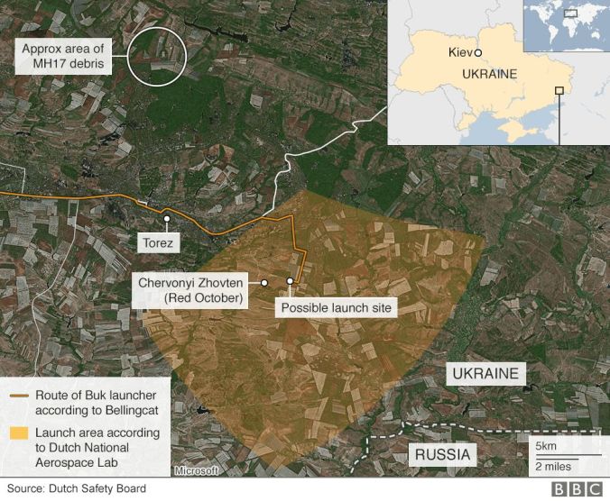
DSB report fig. 62, section 3.8.6. In an area of 320 square kilometers, as calculated by the NLR, the missile launch had to be found.
6.3 Criticism to the results
So two things are very important here: 1. the visual damage assessment; how it is done and what conclusions are drawn from this, and 2. modeling of the ¨Black Box¨; how the simulation is designed, i.e. how weapon performance is modeled (payload qualities, fragmentation dispersion, velocity profiles, working of the proximity fuse, trajectory adjustment, etcetera). It is obvious the procedure mentioned first can be assessed more easily by an outsider than the latter.
Alarmed by an initial draft of the findings, the Russians probably spurred Buk company Almaz Antei to come up with counter-evidence. They produced a competitive technical report, presented on the same day as the DSB report. It showed their own damage pattern analysis on MH17, field experiments with a detonating Buk missile and trajectory simulations. [See the slide show from Almaz Antei]
To start with the similarity of both studies, neither party contested a missile blew up at a point left at the upper side of the cockpit. This finding would entail the exclusion of large parts of the plane being harmed by fragment spray – i.e. the main part of fuselage, especially at the right side, tail sections apart from the stabilizers, but also the cone shaped nose of the aircraft.
Obviously, there were also differences, some very illuminating, although in the end Almaz’s findings perfectly matched satellite imagery of Ukrainian Buk vehicles in the conflict area which Russia had produced before. These differences will be addressed below, as the Buk manufacturer came into the game after the NLR came to the conclusion that it was a Buk that had been fired.


Top: Two Ukrainian Buks allegedly standing in a farm field just south of Zaroshchenske village, published by the Russian Ministry of Defense in a press conference held on July 21, 2014;
Bottom: Calculations by Buk manufacturer Almaz Antei showing the most probable launch areas, south east from Zaroshchenske, near Velyka Shyshivka/Bolshaya Shishovka.
Based on damage assessments the NLR ruled out that an air-to-air canon with high explosive rounds of several origin (App. X, NLR, section 4) or a R-60 missile as mounted on a SU-25 (App. X, NLR, section 5) were used. With respect to the surface-to-air scenario, only Buk types were reviewed. So the NLR ended their search for used weapon with a Buk using a 9N314M warhead really easily, based on the bowties, dismissing without much attention a scenario supporting another fragmentation/blast weapon.
TNO was asked by the DSB to perform analysis with a lower weight payload, consistent with other missiles, including air-to-air ones, but they had to use parameter values that were optimized for the Buk. Not unexpectedly the result showed a worse match of the damage pattern than a detonated Buk warhead (App. Y, TNO, section 5.4).
Furthermore, the research lacked investigation into the metallurgical composition of the bowties and other found fragments of a presumed Buk fragments. As the preformed elements of the warhead have been made of unalloyed steel, the used steel might have some important things to say about type of warhead and might also provide an answer to the question if the bowties belonged to the same payload as the other found fragments.
And my blog post https://hectorreban.wordpress.com/2015/10/28/the-mh17-13-october-verdict-dsb-versus-almaz-antei/
The DSB responded to questions from the Russians that the Buk manufacturer had stated that steel from different batches of iron ore could have been used to arm the same payload, so there was no need to look into this. This answer was kind of strange as it was pretty certain that, for example, a warhead made in 1986 could not contain steel from a particular iron ore source delved in 1987. The DSB stated in a preliminary draft that “due to the absence of reference material from the mentioned 9N314 warhead preformed fragments, a metallurgical link could not be made.” (DSB, App. V, p. 10; see screengrab below) The Russians advised to skip it and apparently it did not make the final report.

Also practical problems arose based on political choices, as pointed out in the section above. There were not enough relevant wreckage parts available to develop a well designed simulation model (App. Y, TNO, p. 5), especially with respect to the upper left side of the cockpit canopy and the right wing section. The locations of some important roof parts had been found, but apparently these parts had not been recovered as they did not appear in the Boeing model that was showed at the presentation nor in the NLR/TNO appendices to the final report.
The DSB and OM, the prosecutor’s office, provided a list of wreckage parts to be recovered to the National Police, according to the ICCb docs, p. 159, however it is unknown which parts were on that list.

ICCb documents, p. 159: “Return to the crime scene; For thorough investigations three weeks are needed, apart from recovery of the wreckage parts. DSB need a number of specified parts of the aircraft (wreckage parts). The same is true for the OM. NP [National Police] has a list of desired parts.”
TNO wrote in their recommendations it was advisable to perform metallurgical research, use more relevant wreckage parts and conduct research into the damage of the inside of the cockpit (App. Y, TNO, section 6). However, not only limited damage assessment of the inside and outside of the cockpit influenced the final results, also the type of shrapnel markings at the boundaries seemed to have been attributed falsely by the NLR.
The boundaries and type of hits between affected and non-affected areas (grazing, ricocheting or tangential) played an important role in the damage assessments, as they could say a lot about the proximity and orientation of the detonation. Many people, technically educated engineers and others showed that the position of this key variable, was established way too far away from the plane and too high (~z-value) as well.
Contrary to the DSB Almaz had done damage analysis of the inside of the cockpit. They used the large difference between hits in the left side floor and in the right side floor and also looked into hits along the longitudinal axis of the plane (axis from nose to tail) to explain their deviating results. The company remarked that these last hits hit the mainframe, eventually causing the cockpit to break off. However, they claimed, this could not have been inflicted by a warhead orientation compliant to a south from Snizhne launch trajectory.
Another finding seemed important too. After a field experiment, in which a Buk was detonated from a Snizhne compliant orientation towards an Ilyushin cockpit, it was found that some high energy particles had penetrated the right side of the cockpit hull. Those had pierced the cockpit twice, going in and out again. According to damage assessments there were no such fragment holes found on MH17.
All in all it seemed the damage pattern analysis, which NLR and TNO performed, was based on shakey grounds, as TNO more or less confirmed in their recommendations.
Also the impression was raised that the data as calculated by the NLR had been optimized for the south of Snizhne launch scenario. TNO had to work out their own similation procedure with the input of the south of Snizhne compliant data from the NLR (App Y, TNO, p. 4). With these data also conditions for their simulation procedures were laid out (App Y, TNO, p. 18), of which some were remarkable.
First one was that they had to consider no hits by preformed fragments in the left wing section and, second, neglectable damage to the right wing section. Apart from the wingtip, which was unharmed, the right wing was not even recovered. Next to that, Almaz showed pictures of the left wing nacelle, which “bore brunt of preformed fragment damage” [Slide show, Almaz Antei , p. 11-14], not at all reconcilable with a Snizhne launch.
It is fair to say that the conclusions of the DSB report showed problematic results. Not only by comparing them with some of the Almaz findings, but also by looking at a 2-dimensional model of Buk fragmentation spray [designed by Mick West, administrator of metabunk.org], it was plausible to assert that some of the found damage – or in fact its unexpected absence – could not be explained with a south of Snizhne launch scenario [For more discussion, see my blog post].
Furthermore, it was unclear why the DSB apparently had decided to cut off a part of their calculated launch area [see explanation in a gif file by Micha Kobs], right at the south-west side of the area they showed to be of interest in their report. Apart from a narrow strip at its most southern part [see pdf], also this cut off part was front area or controlled by the Ukrainian army.

It is unknown why a part of the launch area as calculated by the NLR was cut off.
6.4 Other parties involved: US and Ukraine
The United States, as leading NATO power with superior monitoring capabilities, didn’t hand over a lot of hard forensic evidence to build upon. First, the Airborne Warning And Control System (AWACS), which operated at the western borders of Ukraine from Poland to Rumenia, could not provide sufficient data. According to the DSB final report they had lost track of MH17 half an hour before it was shot down (p.44).

Furthermore, the US could not provide imagery made by drones. These drones may have been operating in Ukraine to assist in i.e. surveillance operations as part of the NATO-Ukrainian Distinct Partnership Agreement. However, the US stated that there were no US drones present at that time, because of “strategical motives”. According to documents from the ICCb (p. 5-6), therefore “no imagery from US drones would be available for the DSB investigation”.
A striking conclusion that had to be drawn from the DSB final report was the fact that there had been conveyed just enough information to blame the pro-Russian side in the conflict, without exactly pinpointing a specific launch site of a Buk missile. The NLR had provided the DSB with a launch area of interest of about 320 square kilometers, a pretty vast area, and apparently had cut off even a part too, as pointed to before.
This proved one or two things. First, on Aug. 12, 2014, Secretary of State John Kerry made a bold statement about the Buk anti-aircraft missile suspected of downing the plane:
“We saw the take-off. We saw the trajectory. We saw the hit. We saw this aeroplane disappear from the radar screens. So there is really no mystery about where it came from and where these weapons have come from.”
In an interview for Dutch state television DSB chief Tjibbe Joustra moved very cautiously to questions about the satellite imagery the US would have in possession to back up the claims Kerry had made. His answers could be labeled pretty evasive and vague:
At about minute 13:00 the quotation from John Kerry appeared:
Interviewer: Have u seen these images?
Tjibbe Joustra: We have seen various images containing classified information.
Int: Also these [referring to the ones Kerry mentions]
TJ: Err… err…, the images we have seen that are classified, I am [legally] restrained too, and so I am not going to tell which ones they are exactly and what is shown on them.
Int: The boss, or the leader, of the investigation led by the Prosecutor [Westerbeke], at the end of last year if I recall correctly, has said it was a fairy tale, a misunderstanding these images existed.
TJ: We have, err…, with respect to the images, seen what we needed. We have done this, err…, via the secret services; There has been an agreement that I myself and another member of the Board could see those images, that we could use the results in our reports, but that we don´t respond to, err…, what exactly it is we have seen.
Int. But have you seen that material?
TJ: We have seen material which confirmed to us sufficiently what was going on [Joustra seems to phrase his answer as if he is referring to classified material in general of which the US imaging may or may not have been part; HR]
Int.: Was it possible to see the location of the launch on them?
TJ.:Well, it was classified information, so I won´t go further into the content of this information.

Obviously, this could not clarify anything about the value of the US cooperation, other than that it had not led the DSB to narrow down their area of interest. In a section of the report, About the Investigation, p.66, it said: “The findings of the DSB (…) agree with the classified information”, which sounded a lot like the vague response to the finding of the Akkermans bowtie fragment.
According to JIT chief Fred Westerbeke the people were obviously led by some misunderstanding:
“There are no satellite images in the sense of a video on which you can see a missile take off. There is no conclusive evidence known at the intelligence services with the answer to all questions. ”
However, after the final report was presented this would not impair him to claim that now the JIT was dealing with murder.
From early reports on several US new networks after the crash, it seemed that the satellite intel the US was referring to was based on information from a so-called Space Based Infrared System (SBIRS), a system that is able to detect the radar activity and heat signature of a launched missile.
Marcel van den Berg, administrator of whathappenedtoflightmh17.com, wrote a primer on the topic. Also limitations were addressed:
“The SBIRS satellite uses infrared sensors to detect the heat exhaust of the missile. Water vapour obscures infrared, which means the cloud cover at July 17 might have blocked detection of the initial launch phase of the SAM. Also sunlight is reflected by clouds which can disturb the vision of SBIRS.”

The weather in the area was cloudy when the plane was shot down – the cloud-base in the area varied from 1000 tot 3000 meters high – and US satellites could not have picked up radar signals of the launch [explanation]. So no full missile trajectory was seen by the SBIRS. Therefore the origin of the launch had to be projected by calculations, as also a CBS News animation showed with a dotted line (see below).

On July 22nd, the Pentagon issued a picture with imagery that looked like parts of satellite captures. On the imagery a green line was drawn in from the location of the hit to some point on the ground, obviously representing the missile trajectory. On the ground it said “Snizhne”. This has been the only alleged evidence related to MH17 the US ever ceded to the public (see below).

NATO was providing all sorts of assistance to Ukraine in a joint partnership, including in airspace surveillance and propaganda:


Although the missile trajectory on the map seemed to have been drawn in manually and was not kind of a computed result, Bellingcat even tried to “geolocate” the origine of this line on the ground, as if the US Department of Defense had put in some serious secret clues where to find the exact launch spot.
This way they found out the American information almost matched the launch site that Ukraine@war and Roland Oliphant had found a day before, based on the photo of the alleged launch plume (see also part 2, section 2.1). However, the DSB – that never mentioned Bellingcat even once in their reports – did not use this information to come up with a narrowed down launch area or even a specific launch spot.
The JIT would take on an entirely different approach to all this. After a press conference on September 28, 2016, information was published on their website, alluding to the same American information:
“In response to a Dutch request for legal assistance, the US submitted a report in which they present their assessment of the information regarding the shooting down of flight MH17. This report can be used in court.
The conclusion of the American authorities is that flight MH17 was shot down by an SA11 surface-to-air missile, i.e. a BUK missile, which was launched from a site about six kilometers south of the village of Snizhne in Eastern Ukraine.
This is consistent with the distance to aforementioned launch site near Pervomaiskiy. The US also explain how they reached this conclusion.”
The conclusion drawn from the DSB final report – the launch plume photo had not been used to specify a particular launch site – gave dissident voices some leverage. According to them a lot was wrong with the launch plume picture leading to this Pervomaiskiy farmland. With simple calculations it could be established the plume, photographed 3 minutes after the launch from 12.3 km distance (home of the photographer), had a width of at least 90 meters, about 10 times the width of its origin. This would mean it was diluted 100 times, but still visible after this time and distance – a very unlikely natural phenomena.
Furthermore, it seemed to exist of two parts – a part of black smoke and a part of a white trail. Two forensic analysts argued with physics the black part, which curled up neatly fitting into the white, was unrelated to the other part [see my report The trail that was not a launch plume, p. 14 and p. 33]. Only two years later Bellingcat’s Daniel Romein confirmed this, shifting to another ludicrous assertion. The black smoke had been a back-blast from dust after launch, according to him.

Left: Romein’s launch plume article in which was claimed that the origin of the launch was located at the origin of the black smoke, causing the plume to make a sharp turn.
Right: Romein claiming two years later the black smoke was a back-blast from dust at launch.
Because two pictures of the plume – one unzoomed, one zoomed in – were captured within 7 seconds apart, the drift of this plume from its origin at the time of the launch could be calculated back, using the speed of the wind in the area. Micha Kobs showed with clear physical mathematics, that if it depicted a Buk launch, the actual origin had to be found even south from the tiny village of Pervomaiskyi, more than 15 km. away from the photographer’s residence. These results made the entire story collapse, as the plume pictures obviously showed an impossible launch site.

After a thorough determination of the wind speed over the area, Micha Kobs calculated to the origin of the alleged Buk launch plume as seen on the @rescuero pictures. This was a site south-east from Pervomaiskyi. See The Impossible Launchsite, part 2, p. 10. This result needed further analysis, according to Kobs’s concluding remarks.
I officialy presented this and other plume studies to the Dutch police, who visited my blogsite once to never come back again. Contrary to these calculated facts, the JIT corroborated the Ukraine@war /Oliphant launch site with more confirmation from hearsay:
“The Dutch Military Intelligence Service (MIVD) and the (Dutch) National Public Prosecutor on Terrorism have been able to view the underlying state-secret (intelligence) material and based on that information and the explanation provided, they support the fact that this conclusion is drawn.”
Notice the formulation. I also support the fact that this conclusion has been drawn, but I do not support the conclusion itself. Setting this aside, the explanation the US provided is apparently the key for understanding all the imagery. However, as I addressed in part 1, added text (or words) mean everything when interpreting imagery.
Last line the JIT wrote about US assistance was this one:
“In addition, they mention that they are sure of the fact that the Ukrainian air defence systems could not have done it and that an air-to-air scenario is impossible.”
Ukraine just could not have done it, the Americans claimed. That settled this issue. Until publication of this blogpost this was the only reference ever made by the JIT to a scenario in which the Ukrainian army could have made a mistake or shot down the plane deliberately in a “false flag operation”. The JIT never spent another word about the possibility of a Ukrainian Buk captured by the separatists or one used by themselves.
Speaking about Ukraine, as said above, they did not assist the JIT in performing field experiments with Buks. What they did provide was an unbelievable concise calculation of the launch area of interest. Whereas the DSB had to settle for 320 square kilometers, the Kyiv Institute for Scientific and Forensic Research showed an area of about 4 square kilometers (!), with the Oliphant field exactly at its core (DSB final report, p. 154; see image below). Not unexpectedly, the used parameters and values for detonation point and missile orientation were not disclosed in the DSB report.


The calculation made by Kiev was utterly suspicious. The Institute, especially its director, Alexander Ruvin, was embedded in suspicion of fraud as it was. Ruvin allegedly was an opportunist who had already occupied his position during the Yanukovich years. The Director and his Institute were believed to have provided false evidence in the case against pro-Maidan politician Yulia Timochenko and others.
He was also accused of corruption and running a “smuggle syndicat”, according to some media. In 2016 there even was an attempt on the life of what Ukraine Today called “the chief investigator in the most high profile criminal case”, meaning the MH17 case. Censor.net chief editor Yuri Butusov, who had leaked information from the investigations more than once, heralded Ruvin as the hero of the MH17 case.
From the outside, everything the Institute touched must be assessed as forensically contaminated, maybe even including the retrieval of the bowtie from the captains body.
The administrator of whathappenedwithflightmh17 wrote a oversight of the identification procedure. The bodies of the people found near the crash site of the cockpit, so including the crew present there at the time of the hit, were sent to Kharkiv. The Ukrainian official Andrey Lysenko had stated that all facilities were available in Kharkiv, which probably meant the Kyiv Forensic Institute was also present to facilitate and supervise proceedings. On arrival all bodies were scanned in an X-ray machine to make sure there were no bombs in the body bag.
A year after the crash ultra-nationalist outlet censor.net published photos from the procedure. One showed an X-ray photo of the body of a crew member, another the bowtie that had been retrieved from the captain’s body (although the article claimed it was from a wreckage part).

According to censor.net they had received the photos from attorneys of the next of kin of the victims, but more plausible would be that someone present in Kharkiv or in Hilversum, where the Dutch subsequently supervised the autopsy and identification, had leaked the information to them. Obviously, publication of the photos would move the outcome of the international debate “Buk or no Buk” decisively towards the (Ukrainian) position that a (Russian) Buk had been the murder weapon.
Chief editor of censor.net Yuri Butusov was a personal friend of Anton Gerashchenko, advisor for the Interior Ministry, the department that had political control over the SBU. On July 11, 2014, Geraschenko and Butusov presented a charity fund at the Ukrainian Crisis Media Center, a so-called “joint civic initiative”, named the All-Ukrainian Charity Fund for Strengthening the National Security of Ukraine. The purpose of creating this fund was, according to censor.net, “to create a tool for years to come through which civil society can finance specific measures to strengthen the National Security of Ukraine.”
So Butusov, who controlled censor.net, was in business of Homeland Security together with an official of the Interior Ministry with a position very close to the SBU. It was the SBU that provided the security of the site in Kharkiv where the bodies were collected in a plant of a weapon manufacturer. Through these connections it seems possible Butosov got the X-ray photo, but also the photo of the bowtie that allegedly had been retrieved from the captain’s body. The Dutch also took a few X-rays but mostly CT-scans of the bodies when they performed autopsies in Hilversum, the Netherlands. It was a possibility the X-ray originated from the plant in Kharkiv. The question remained how Butusov received the bowtie photo, when ultimately the autopsies were done in Hilversum.

Censor.net: The bowtie from cockpit wreckage, according to Butusov, is the same as the DSB final report showed in the upper right corner of the image on the right. However, the DSB claimed this bowtie was recovered from the captain’s body. Question is how the X-ray and bowtie photos ended up at the desk of Yuri Butusov, chief editor of censor.net and personal friend of Anton Gerashchenko. Were there leaks from Kharkiv or Hilversum? And to what extent was the forensic investigation compromised or contaminated by these presumed leaks?
From the JIT e-magazine, June 2016:
Immediately after the crash in July 2014, the remains of the victims came to The Netherlands. In the Korporaal van Oudheusden barracks in Hilversum the identification of human remains takes place. Simultaneously, within 24 hours an additional ‘street’ with X-ray and CT Scan equipment is set up on the site for the criminal investigation. Radiologists keep their eyes fixed on X-rays and CT scans to identify any foreign material.

To wrap things up, one might conclude there are reasons to doubt the results of the technical research commissioned and led by the DSB. In the first place the investigations seem to have been influenced extensively by political incentives to come up with a desired outcome the JIT could work with. Type of weapon and launch area calculations seem to have been tailor-made to confirm the “main scenario” the JIT was following, based on framing of a fatal mistake narrative and the SBU connected OSINT and intercepts (see parts 1-5 of this series).
Furthermore, there could be no doubts about the lack of confidence the people (or the judge for that matter) should have about the Ukrainian forensic research team and their presence during the autopsy and identification procedures. It is clear parts of the Ukrainian state, i.e. the Kyiv Institute for Scientific and Forensic Research and the SBU, bodies with well circumscribed interests to serve official anti-Russian political objectives and both known for their corruption, had a decisive influence on the way the JIT investigated the disaster of flight MH17.
6.5 Ukraine got of the hook
What the DSB final report also provided, was fierce criticism on two topics. First, risk analysis as performed by the players involved and layed down in ICAO regulations – which were the airway company, the (inter)national regulative bodies, the intelligence agencies and their international partners (US, NATO) – was severely flawed. And, secondly, Ukraine was to blame for not closing the airspace above 32,000 feet, as they only considered the interests of their own military aircraft, setting aside the vulnerability of civilian flights cruising above the ceiling. (see screenshot below, DSB final report, section 9.2)

Actually, this criticism was pretty devastating for Ukraine, as it clearly accused them of culpable negligence resulting in the death of 298 people. However, this second conclusion was overshadowed by the first. Ukrainian culpability was flooded in criticism to an overall failure of the system of risk-assessment management, apparently leading Het Openbaar Ministerie (Dutch prosecutor’s office) to invoke the opportunity principle by not prosecuting Ukraine for their misconduct. So also here Ukraine got of the hook and resided to being part of the JIT as its main provider of doubtful evidence.
In July 2019 Dutch commercial network RTL wrote the government was not pushing prosecution:
“The government has not taken any steps against Ukraine so far. As far as is known, nothing is happening behind the scenes. The government is trying to maintain a good relationship with Ukraine, also because of the intensive cooperation in international research. Last year the Netherlands, together with Australia, decided to hold Russia liable as a country.”
After this the indignation of the Dutch people rose – at about 85% would be in favor of prosecution of Ukraine for not closing airspace – and in Parliament pressure mounted. Maybe this case is still open for debate.
As to the analysis of possible threats arriving from a warzone, the regulations and conduct of involving parties showed a nice example of a so-called Catch 22. The documents provided by the Dutch crisis control center ICCb show a fine representation how this policy led to all involved parties blaming each other.
The threat analysis – determining the possibility of a threat occurring – ultimately depended on two criteria. First, do the warring parties have potential capabilities to cause any threat, and, second do they also have INTENTION to use these capabilities against civilian aircraft? This says capability on its own does not by definition imply risks for civilian flights.
In this case Ukraine had capabilities but apparently, according to the risk assessments, no intention. Furthermore, the separatist had no capabilities on the 17th, as was assessed by Dutch intelligence agencies. And even if they had, intention was not present, as there had been no examples in history in which a civilian airplane was downed on intention! [ICCb, p.94] This way the conclusion was that “according to the criteria held there was no threat in East-Ukraine against civilian airlines” [ICCb p. 94 ].

ICCb documents, p.94, in bold: “Conclusion: According to the criteria held there was no threat in East-Ukraine against civilian airlines. As known thus far downing of a civilian airplane was not intended and MH17 has been downed by accident.”
Of course this is a clear example of Kafkaesque reasoning. There is no intention because there never has been established intention before, resulting in the premise that there is no intention, because intention never happens. Capability does not invite risk on its own, but the second necessary requirement, intention, can never be established.
So, first, this system for risk assessment left out any possibility of unusual, but reasonably to be expected misconduct or mistakes, i.e. raised by increased activity of the warring parties. “Unintentional consequences of human action stayed out of consideration” [ICCb, p. 263]. In other words, false flag operations were non-existent and also fatal mistakes didn’t enter the realm of actual risk-management in matters concerning the airspace.
In case something actually does happen, this automatically leads to a fatal mistake narrative, (unless intention can be proven). Because the separatists and Russia – contrary to Ukraine – lacked any sound motive for intentionally shooting down a civilian aircraft, not even in a scenario of a false flag operation, the disaster had to be inflicted by “unintentional human action”, an anomaly like a mistake.
Second, and this was most astonishing, the rule-book left out every possibility that a befriended nation with capabilities – Ukraine – could engage in risky or intentional dangerous operations that would ever lead to a no-go advise based on capabilities alone. This sounds very ominous, though is a matter of convenience. If the international agencies that monitor airspace should advise closure or non-departure on every occasion a nation that has to be passed over is in possession of medium or long range air-defense missile systems, no single plane would ever leave the airport.
In the system of regulation ultimately the airway companies should decide where to fly, within the boundaries set by official closures of the airspace. The DSB recognized the predicament Schiphol Airport and Malaysian Airways were in, as they concluded that “most operators concluded that an airspace that was not closed, was safe” (section 9.2). This moved responsibility, concerning the policy Schiphol had pursued, to the Dutch intelligence community.
However, the CTIVD (Dutch intelligence supervisory commission) concluded the Dutch intel services received no indications that the separatists had threatening air-defense capabilities on July 17th (p. 24). They had reviewed the information coming from the Ukrainians regarding the downing of an AN-26 cargo plane on July 14th and a SU-25 on July 16th. From this they concluded, based on damage assessments and contrary to the DSB report, these planes were not downed at high altitude and so there was no evidence a medium range missile caused these crashes.
 DSB listed the planes that were downed by the separatists, including two alleged high-altitude hits.
Furthermore, as was stated in the ICCb documents (p. 135):
“When the NCTV (National Coordinator Terrorism Control) receives information from international partners, it will be presented to the AIVD (Dutch central intelligence agency) for verification”.
Apparently, as from the CTIVD report could be concluded, no information surfaced from those partners that the separatists were in possession of threatening capabilities. This shifted the blame further to them, i.e. the ones with superior intelligence capacity, like the US and NATO.
In fact, the US had forbidden American airline companies to fly in the airspace above the conflict area in Eastern Ukraine in April 2014. The policy was not based on the presence of air-defense missile systems, though, but on the perception that “there was an unsafe situation in the area of the conflict, the Sea of Azov and the Crimea, where both Ukraine and Russia claimed control over the airspace”. This would raise the possibility of “contradicting instructions and flawed identifications of civilian aircraft” in these parts of the airspace, according to the American authorities.
In this blame game the US, and NATO in particular, responded as if they were stung by a bee when the president of the Royal Dutch Airline company (KLM), Camiel Eurlings, stated: “KLM was not aware of the presence of advanced missile systems in Eastern Ukraine. KLM neither had any knowledge about other airline companies that were avoiding the airspace over the conflict area”.
According to Eurlings:
“Information that other airline companies behaved differently was unknown to me. It was just a route that was declared safe. The impression that one would be safe on a height of 10 kilometers, appears to be wrong considering this kind of sophisticated missile systems.”
A KLM spokesperson added: “If there were any clues the airspace was unsafe, we would have decided not to fly.” It is just like driving a car. If a road has been closed, you look for another route.
This was consistent with the conclusion from the DSB final report section 9.2, mentioned above, and also from the ICCb documents, which provided a short overview of companies that did not fly over Eastern Ukraine. Most companies assumed that when the airspace was not closed, it was safe. The only companies that didn’t fly, acted on behalf of other, more general – and probably political – concerns.
According to the ICCb documents (p. 7) a high ranked military official of NATO responded to the statements from KLM chief Eurlings by stating:
“NATO did warn! Even after the rebels shot down a dozen aircraft of the Ukrainian airforce out of the sky, KLM nor other companies adapted their flight routes. In a press conference in the Pentagon on June the 30th general Breedlove spoke in clear wordings about the risk posed by anti aircraft missiles. His warnings have been published over the entire world. NATO can’t act more proactively. People cannot expect from us that every morning we phone up hundreds of airline companies to cancel tens of thousands of flight plans”.
So by these preposterous assertions the merry-go-round shifting of the blame arrived at the airline and airport companies again. Notwithstanding the moral impact – the fact that blame is put on the lowest tread on the information ladder – the assertions were also false. No clear warning had been issued on this June 30th presser by Breedlove, who had only suggested that unspecified heavy equipment was being transported from Russia to Ukraine. In fact, Breedlove had to be tickled by reporters to come up with more precise statements, which eventually also did not reveal any specific and direct warnings.
As a matter of fact in a reply to questions he said about presence of air-defense missile systems: “We need to allow the facts to be sorted out before I report it. (…) We have not tied the strings together yet” [on Russia’s involvement in the shoot down of Ukrainian aircraft]. See the screengrabs from the transcripts of the press conference below.


The airline companies and airport managers pointed to the national secret services; these implicitly relayed blame to their American partners and NATO who had many more capabilities; and US/NATO threw it back to the airline companies again. One party, who had its own responsibilities, got of the hook somehow in this embarrassing display of shifting blame. This was Ukraine. When it’s everybody’s fault, it’s no-one’s fault.
Although everyone pointed to the other, ultimately they also shared interests. NATO tried to wash their hands in innocence in a shameful Pontius Pilatus play, but it is clear they did not issue a specific warning about threats posed by medium to long range surface-to-air missile complexes. Every entity that shared responsibility, Ukraine, NATO, US, Dutch government – and foremost their secret services – all had an interest that there was no Buk present before July 17th. This way some “plausible deniability” could be invoked that all these parties – foremost Ukraine – had been taken by a surprisingly bold and sudden move from Russia.
Of course Ukraine had tried to suggest on two occasions planes were hit at high altitude to get more leverage from EU and NATO. But ultimately after MH17 crashed they back peddled to play out the narrative of a Russian Buk that moved in and out Ukraine within a day, a narrative that was fully supported by the JIT and the DSB.
